
India, one of the world's most ancient and living civilizations is the 7th largest country in the world. With 2.4 per cent of the total surface area of the world, many of the Indian states themselves are larger than a number countries of the world.
The geography of India is a showcase of diversity as it's landscape varies from snow-capped peaks to deserts, plains, rainforests, hills, and plateaus. From the highest mountains in the world to a vast coastline of over 7000km, from the barren and hot Thar desert to the second coldest inhabited place on earth...India has a number of interesting geographical facts in it's book.
Here's a look at some interesting facts about Indian geography:
Tallest Mountain in India: Kanchenjunga
 Kangchenjunga is the third highest mountain in the world (after Mount Everest and K2) and the tallest peak in India, with an elevation of 8,586 metres (28,169 ft). "Kangchenjunga" which lies in the Himalayas means "The Five Treasures of Snows" translated, as it contains five peaks, four of them over 8,450 metres.
 Kangchenjunga is known for its famous views from the hill station of Darjeeling. On a clear day, it presents an image not as much of a mountain but of a white wall hanging from the sky. The people of Sikkim revere Kangchenjunga as a sacred mountain.
Longest River in India: Ganga (Ganges)
 Considered a sacred river to the Hindu's, the 2,510 km (1,560 mi) Ganga river rises in the western Himalayas in the Uttarakhand state of India, and drains into the Sunderbans delta in the Bay of Bengal. The Ganges and its tributaries drain a 1,000,000-square-kilometer (390,000 sq mi) fertile basin that supports one of the world's highest density of humans.
Three towns holy to Hinduism – Haridwar, Allahabad, and Varanasi – attract thousands of pilgrims to its waters. Thousands of Hindu pilgrims arrive at these three towns to take a dip in the Ganges, which is believed to cleanse oneself of sins and help attain salvation. The Ganges river's long held reputation as a purifying river appears to have a basis in science. The river water has a unique and extraordinary ability to retain oxygen.
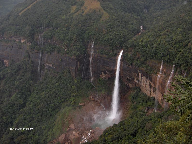
Largest waterfalls in India: Chitrakot
 The Niagara Falls have competition. In the form of Chitrakot, India's largest waterfalls. About 38 km to the west of Jagdalpur, this Chitrakot Waterfallspectacular fall is formed when the river Indravati abruptly collapses into a 100 feet deep cavern. The mouth of the fall, when in full profusion, is over 1,000 feet wide. Chitrakot is a horseshoe shaped waterfall, best seen during and after the monsoon, between July and October. Chitrakot is a horse-shoe shaped waterfall, best seen during and after the monsoon, between July and October.
Largest Glacier in India: Siachen Glacier


Siachen Glacier is the largest glacier in India. At 75.6 km long and 2.8 km wide, it is the longest glacier in the Karakoram and second-longest in the world's non-polar areas.
The Siachen Glacier is located in the eastern Karakoram range in the Himalaya Mountains along the disputed India-Pakistan border. The Siachen Glacier lies south of the great watershed that separates China from the Indian subcontinent in the extensively glaciated portion of the Karakoram. The word 'Siachen' means "the place of wild roses". Siachen also has the dubious distinction of being the highest battleground on earth. The volume of the glacier has been reduced by 35 percent over the last twenty years. Global warming and military activity have been cited as the main reasons for the receding of the glacier.
The Siachen Glacier is located in the eastern Karakoram range in the Himalaya Mountains along the disputed India-Pakistan border. The Siachen Glacier lies south of the great watershed that separates China from the Indian subcontinent in the extensively glaciated portion of the Karakoram. The word 'Siachen' means "the place of wild roses". Siachen also has the dubious distinction of being the highest battleground on earth. The volume of the glacier has been reduced by 35 percent over the last twenty years. Global warming and military activity have been cited as the main reasons for the receding of the glacier.
Highest Rainfall in India: Cherrapunji
Wettest Place in India is Cherrapunjee. In fact, Cherrapunji is the wettest place on the earth receiving the highest rainfall ever. The place receives an annual rainfall of over 1200 cm.
Cherrapunji is situated at 56 kms from Shillong, the capital of Meghalaya, in one of the heaviest rain-belts in the world. However, off late, a ding-dong battle has been on between Cherrapunji and the neighbouring village of Mawsynram for the crown of "Wettest Place in the World". Sometimes, it is Cherrapunji which records highest annual rainfall in the world and sometimes it is Mawsynram. However, meteorologists question the genuineness of the data obtained from Mawsynram. Unlike Cherrapunji, there is no meteorological office at Mawsynram and the readings there are taken by a peon of the Meghalaya Public Works Department posted there.
Cherrapunji is situated at 56 kms from Shillong, the capital of Meghalaya, in one of the heaviest rain-belts in the world. However, off late, a ding-dong battle has been on between Cherrapunji and the neighbouring village of Mawsynram for the crown of "Wettest Place in the World". Sometimes, it is Cherrapunji which records highest annual rainfall in the world and sometimes it is Mawsynram. However, meteorologists question the genuineness of the data obtained from Mawsynram. Unlike Cherrapunji, there is no meteorological office at Mawsynram and the readings there are taken by a peon of the Meghalaya Public Works Department posted there.
Coldest Place in India: Drass, Ladakh
 Drass in western Ladakh is the coldest place in India. It is also the second coldest inhabited place in the world after Siberia.
 Situated at an altitude of 3230 m, Dras lies 60 km west of Kargil on the road to Srinagar in Kashmir. Temperatures can drop down to about -45 degrees Celsius in winters. However, summers in Drass are balmy and many trekkers and campers visit Drass during the summer time. The Drass valley starts from the base of the Zojila pass, the Himalayan gateway to Ladakh. Drass is a convenient base camp for treks to Suru valley.
Smallest State in India: Goa
 Goa with an area of 3702 sq. km is the smallest State in India. Goa was a Portuguese colony and was liberated from Portuguese rule on December 19, 1961. After its independence Goa along with Daman & Diu was accorded the status of Union Territory. On May 30, 1987, the Union Territory was split, and Goa was elevated as India's 25th state, with Daman and Diu remaining Union Territories. Goa is one of the most developed states of India. Tourism is the mainstay of Goa. Panaji is the capital of Goa and Vasco is its largest town. The main language of Goa is Konkani.
Largest State in India: Rajasthan
 Rajasthan with an area of 342,239 sq km is the largest state in India. Before the formation of Chattisgarh as a separate state in the year 2000, Madhya Pradesh was the largest Indian state in terms of area. Rajasthan is located in the western part of India and has two distinct geographical regions with desert on one side and thick forest on the other. Aravalli the oldest mountain chain is the dividing line between the two climatic zones of the State. Western Rajasthan encompasses most of the area of the Great Indian Desert (also known as Thar Desert). The eastern region of the State has thick vegetation of Sal, Axlewood, Dhak and Mesquite.
State with the highest population: Uttar Pradesh
 Uttar Pradesh is the state with maximum number of districts in India. It has a total of 70 districts. Uttar Pradesh is the most populous and fifth largest state of India. Only five countries of the world, China, the United States, Indonesia, Brazil and India itself have populations larger than that of Uttar Pradesh. Kanpur is the largest city of Uttar Pradesh and as per the 2001 census six cities of Uttar Pradesh, namely, Agra, Allahabad, Kanpur, Lucknow, Meerut, and Varanasi have population of over million.
No comments:
Post a Comment